


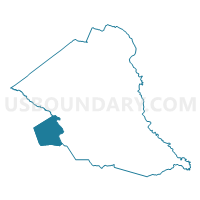
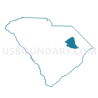
Olanta Voting District, Florence County, South Carolina
About
Outline

Summary
| Unique Area Identifier | 665707 |
| Name | Olanta Voting District |
| County | Florence County |
| State | South Carolina |
| Area (square miles) | 34.51 |
| Land Area (square miles) | 34.50 |
| Water Area (square miles) | 0.01 |
| % of Land Area | 99.98 |
| % of Water Area | 0.02 |
| Latitude of the Internal Point | 33.92464620 |
| Longtitude of the Internal Point | -79.90772090 |
Maps

Graphs
Select a template below for downloading or customizing gragh for Olanta Voting District, Florence County, South Carolina


Neighbors
Neighoring Voting District (by Name) Neighboring Voting District on the Map
- Barrineau Voting District, Clarendon County, SC
- Hicks Voting District, Clarendon County, SC
- McAllister Mill Voting District, Florence County, SC
- Oak Grove-Sardis Voting District, Florence County, SC
- Pergamos Voting District, Williamsburg County, SC
- Salem Voting District, Florence County, SC
- St. John Voting District, Sumter County, SC
- Turbeville Voting District, Clarendon County, SC
Top 10 Neighboring County Subdivision (by Population) Neighboring County Subdivision on the Map
- Olanta CCD, Florence County, SC (3,879)
- Turbeville CCD, Clarendon County, SC (3,527)
- Sardis CCD, Florence County, SC (2,978)
- Cades CCD, Williamsburg County, SC (2,409)
- Shiloh CCD, Sumter County, SC (2,349)
Top 10 Neighboring Place (by Population) Neighboring Place on the Map
Top 10 Neighboring Unified School District (by Population) Neighboring Unified School District on the Map
- Florence School District 1, SC (96,463)
- Sumter School District 2, SC (57,252)
- Williamsburg County School District, SC (34,423)
- Florence School District 3, SC (20,584)
- Clarendon School District 3, SC (6,808)
Top 10 Neighboring State Legislative District Lower Chamber (by Population) Neighboring State Legislative District Lower Chamber on the Map
- State House District 60, SC (34,706)
- State House District 64, SC (34,361)
- State House District 101, SC (29,972)
Top 10 Neighboring State Legislative District Upper Chamber (by Population) Neighboring State Legislative District Upper Chamber on the Map
- State Senate District 31, SC (97,972)
- State Senate District 36, SC (84,337)
- State Senate District 32, SC (81,778)
Top 10 Neighboring 111th Congressional District (by Population) Neighboring 111th Congressional District on the Map
Top 10 Neighboring Census Tract (by Population) Neighboring Census Tract on the Map
- Census Tract 24, Florence County, SC (3,879)
- Census Tract 9601, Clarendon County, SC (3,527)
- Census Tract 25, Florence County, SC (2,978)
- Census Tract 9701, Williamsburg County, SC (2,409)
- Census Tract 5, Sumter County, SC (2,349)
Top 10 Neighboring 5-Digit ZIP Code Tabulation Area (by Population) Neighboring 5-Digit ZIP Code Tabulation Area on the Map
- 29560, SC (13,664)
- 29161, SC (11,383)
- 29591, SC (5,467)
- 29162, SC (4,122)
- 29080, SC (3,240)
- 29114, SC (2,190)